HURRICANE IRMA AND HURRICANE JOSE – SITUATION REPORT #3
Report from the Caribbean Disaster Emergency Management Agency (CDEMA) as of 9:00PM AST on 8th September 2017
Saturday, September 9, 2017 — Irma is currently a category 4 hurricane now moving into the Bahamas. Irma made direct landfall over the Turks and Caicos on Thursday September 07, 2017 with heavy rainfall and recorded wind-speeds of 150 mph and greater. Jose remains a dangerous category 4 hurricane as it moves closer to the Northern Leeward Islands.
Hurricane Irma Appeal
- Persons wishing to donate to will be able to do so through a fundraising drive which will be opened shortly. Please see OECS Website shortly for details on how you can make a valuable contribution.
EVENT:
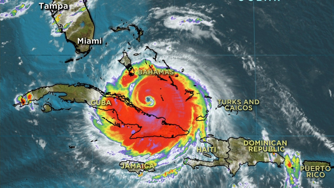
On Friday September 08, 2017 at 800 PM EDT (0000 UTC), the eye of Hurricane Irma was located near latitude 22.2 North, longitude 77.2 West. Irma is moving towards the west near 12 mph (19 km/h), and a turn toward the northwest is expected by late Saturday. Maximum sustained winds are near 155 mph (250 km/h) with higher gusts. Irma is a category 4 hurricane on the Saffir-Simpson Hurricane Wind Scale. Hurricane-force winds extend outward up to 70 miles (110 km) from the center and tropical-storm-force winds extend outward up to 185 miles (295 km). The estimated minimum central pressure is 925mb (27.32 inches).
PROGNOSIS:
The National Hurricane Center (NHC) indicates that on the forecast track, the eye of Irma should continue to move near the north coast of Cuba and the central Bahamas tonight and Saturday, and be near the Florida Keys and the southern Florida Peninsula Sunday morning. Some fluctuations in intensity are likely to continue during the next day or two, and Irma is expected to remain a powerful category 4 hurricane as it approaches Florida.
SUMMARY OF WATCHES AND WARNINGS IN EFFECT:
A Hurricane Warning is in effect for...
Central Bahamas and Ragged Island
Northwestern Bahamas
HURRICANE JOSE:
At 500 PM AST (2100 UTC), the eye of Hurricane Jose was located near latitude 16.7 North, longitude 58.8 West. Jose is moving toward the west-northwest near 17 mph (28 km/h). Maximum sustained winds are near 150 mph (240 km/h) with higher gusts. Jose is a category 4 hurricane on the Saffir-Simpson Hurricane Wind Scale. Hurricane-force winds extend outward up to 35 miles (55 km) from the center and tropical-storm-force winds extend outward up to 140 miles (220 km). The estimated minimum central pressure is 940 mb (27.76 inches).
PROGNOSIS:
A turn toward the northwest with a decrease in forward speed is forecast to begin overnight and continue tonight through the weekend. On the forecast track, the core of Jose will pass close or just east of the northern Leeward Islands. Some fluctuation in intensity, up or down, could occur during the next day or so. Gradual weakening is expected after that.
SUMMARY OF WATCHES IN EFFECT:
A Hurricane Warning is in effect for...
Anguilla
Barbuda
A Hurricane Watch is in effect for…
Antigua
A Tropical Storm Watch is in effect for...
Montserrat
St Kitts and Nevis
British Virgin Islands
The Caribbean Institute for Meteorology and Hydrology provided CDEMA with an impact analysis:
The models of the CIMH are in agreement with the NHC’s projections for precipitation, wind and wave heights expected as a result of the passage of Irma and Jose, specifically CIMH impact analysis indicate:
FLOOD/LANDSLIDE: Model estimated rainfall near 200 mm in the Southern Bahamas. Rainfall associated with Hurricane Jose is expected to be in the range of 100 to 200 mm over the Northern Leeward Islands and decreasing elsewhere. Rainfall amounts are likely to be enhanced due to local topographic conditions. Intense rainfall activity will lead to flash flooding, dangerous river conditions, landslides and debris flows. Flooding is likely to be significantly enhanced within coastal bays due to expected runoff, wave run up, storm surge and tides.
WIND: Winds associated with Irma are expected to produce hurricane force winds with extremely strong gusts in areas of thunderstorms. Hurricane force winds are very dangerous especially in elevated areas and will produce significant damages to infrastructure and life threatening conditions. Winds associated with Jose are expected to produce moderate to dangerous hurricane force winds over the Leewards.
WAVES: Significant wave heights are likely to exceed 8m with storm surge in excess of 4m. Rough seas and damaging waves are imminent, leading to inundation and damages along coastlines and to coastal infrastructure especially in the northern Leeward Islands. Areas to the south could experience rough sea conditions.
NATIONAL UPDATES – POST IMPACT:
Initial reports only are emerging from impacted CDEMA Participating States as of September 08, 2017. These have revealed the following:
ANGUILLA
The airport runway is serviceable for emergency flights
Needs:
No immediate needs were identified
BRITISH VIRGIN ISLANDS
Communications has been restored between the BVI and the CDEMA CU
State of Emergency has been declared
Needs:
Request utilities personnel to restore connections
Emergency relief supplies including, water, canned food, tarpaulin, plywood and sanitary packs
TURKS & CAICOS ISLANDS
TCI sustained significant damage
Damage to households to date is estimated as 70% in South Caicos, 70% in Providenciales and 50% on Grand Turk
Needs:
Anticipated needs are emergency relief supplies including tarpaulin and assessment teams
HAITI
The initial overview indicated, until now, level 1 damage. However a preliminary assessment is ongoing
No deaths reported until now
1 person missing
2 Minor injuries reported
Damage of some roofs
Several persons were evacuated in six (6) geographical regions: North, North-East, North-West, Center, West and Artibonite. In total 2142 persons in 18 shelters
No extensive damages to critical facilities such as airport, hospital etc
No major damage to housing and commercial buildings reported
Some damage to agriculture
Some flooding reported in the northern region
Regarding the Meteorological situation related to hurricane Irma, the all clear is expected to be given tomorrow by the Met service
REGIONAL RESPONSE ACTIONS:
CDEMA Coordinating Unit
An initial CDRU deployment was made to the BVI via two (2) RSS aircrafts on September 07, 2017. The team comprised 9 soldiers from the Barbados Defence Force (BDF)
An eighteen (18) member combined RNAT and COST/CDAC deployment was made to Anguilla and the BVI led by the CDEMA Coordinating Unit and comprised members of Caribbean Tourism Organisation (CTO), Engineers from the Barbados Association of Professional Engineering, Caribbean Media Corporation (CMC), UNDAC, DFID CHASE and PAHO. The teams arrived in Antigua on Thursday, September 7, 2017
The 5th meeting of the RRM Partners was convened today, Friday September 8, 2017 at 1:15pm at the CDEMA Coordinating Unit. The meeting was chaired by CDEMA’s Executive Director. Approximately thirty-five (35) participants from regional and international donor, humanitarian and development agencies were represented
Caribbean Development Bank (CDB)
Emergency Response Grants (ERGs) of USD$200,000 to be made available to Anguilla, TCI, the Bahamas and Antigua and Barbuda
Caribbean Institute of Meteorology and Hydrology (CIMH)
Continue to provide the RRM with daily briefings on weather systems and impact analysis
Regional Security System (RSS)
RSS HQ has issued an initial Warning Order to its Member States to have 15 persons per Force on 24 hours notice to move to deploy to Antigua to conduct disaster relief operations
Two (2) C 26 aircrafts remains on standby to provide reconnaissance, troop deployment and logistical support as required
The Barbados Defence Force and St. Kitts and Nevis Defence Force have been requested to have on standby one (1) offshore patrol vessel each on standby for deployment after the passage of Hurricane Jose.
INTERNATIONAL INSTITUTIONS UPDATES:
European Civil Protection and Humanitarian Aid Operations (ECHO)
Support to the DREF for Antigua and Barbuda (IFRC) EUR 17,530
EU Civil Protection team on stand-by
Copernicus: 28 maps produced so far
ECHO field is closely following developments in coordination with partners – humanitarian experts deployed in Haiti and the Dominican Republic and on stand-by for Cuba and Eastern Caribbean Islands
Global Affairs Canada (GAC)
The Canadian Electrician Company in TCI is working to restore the electricity system
International Federation of Red Cross and Red Crescent Societies (IFRC
Antigua and Barbuda
Distribution of relief items in the collective centres;
Activated Airbus foundation agreement to make helicopter available for assessments and team deployment; 1 General Regional Intervention Team (RIT) deployed to support Antigua and Barbuda Red Cross;
IFRC approved a DREF for 61,418 Swiss francs (CHF);
Preliminary Appeal will be launched
Anguilla
General RIT on standby for deployment to support British Red Cross response
St. Kitts and Nevis
The National Society is conducting damage assessments;
Pre-positioned supplies in 5 areas around the island are being distributed;
IFRC approved a DREF for 64,301 CHF to assist 200 families.
Preliminary Appeal will be launched
Haiti
A team is pre-positioned in northern Haiti and prepared to conduct rapid damage assessments and early-relief operations;
$USD 600,000 worth of nonfood item (NFI) stock is in country and available for distribution.
Currently, mobilizing people and supplies to northern Haiti to support assessment and early-relief operations.
Deployed a RIT and operations manager.
Several vehicles available to undertake assessments in Northern Haiti.
Additional surge on standby to conduct field and sector (Health) assessments as well as emergency hospital deployment if required.
United States Aid for International Development – Office of US Foreign Disaster Assistance
Finalized 100K for Bahamas Red Cross
In the process of finalizing 100K for Antigua and Barbuda
Will be sending a relief flight into Antigua early next week
UNITED NATIONS (UN) AGENCIES
United Nations Development Programme (UNDP)
Prepared to activate crisis preparedness and response plans across the region
Specialists are on standby to accompany governments and relevant partners in needs assessments and early recovery planning
Allocated 300,000USD from its core resources to support assessments, coordination and elaboration of recovery frameworks in affected countries
Experts on debris/waste management, emergency employment and Cash for Work, livelihoods revitalization, core government functions and Post Disaster Needs Assessments are on standby and ready to be deployed
Ready to support national efforts on damage and needs assessments as well as develop early recovery frameworks
United Nations Population Fund (UNFPA)
In collaboration with UN Women, UNFPA is providing Dignity/Hygiene Kits to women and girls in affected communities
Can support in providing life-saving reproductive health commodities through emergency Reproductive Health Kits
Can offer technical guidance on the prevention of Gender-Based Violence and sexual violence in affected communities
United Nations Children Fund (UNICEF)
Offers to support the Ministry of Health in Antigua to cater to the 100 children evacuated from Barbuda
Emergency supplies have been pre-positioned in Barbados to be deployed to Anguilla, Tortola/BVI via Antigua and to Providenciales/TCI
Some supplies have also been pre-positioned in Antigua to be transshipped to the 3 most affected islands
UK AID
The Government of the United Kingdom has pledged £32 million to cover the immediate emergency response needs. There is also a provision through the UK Aid Match II programme for matching public donations up to £5m for humanitarian emergency appeals. There is possible further assistance from UK NGOs
A hotline for calls has been established
RFA Mounts Bay went to Anguilla to provide first line support and ensure further relief can be deployed on 7 Sept and BVI on 8 September. RFA Mounts Bay has shelter kits, water containers and technical capabilities (19 Humanitarian Assistance and Disaster Relief troops)
Six tons of supplies have already been distributed to Anguilla
A deployment of 300 British troops to Anguilla is being planned and should be on island within the next 48 hours
Currently the British Red Cross, Oxfam and UNICEF UK have specific Hurricane Irma appeals and plan to support PAHO (emergency primary healthcare) and CDEMA (transport and immediate response)
DFID humanitarian field teams has been deployed to the region to help with need assessments (including RNAT) and logistics (currently 1 in TCI, 3 in Antigua and 1 Barbados)
Flights carrying relief supplies including further shelter kits, aid buckets and solar lanterns are on their way. A C17 and an A400 airplane have been dispatched
Over the next 24 hours troops and engineers will deploy with helicopters to support the relief efforts in the Overseas Territories
HMS Ocean will arrive to assist with reconstruction after the hurricanes have passed
Office for the Coordination of Humanitarian Aid (UN OCHA)
UNDAC team arriving in Jamaica to support assessments in TCI and Bahamas (includes MapAction and IHP)
World Food Programme (WFP)
Providing communications and logistics support
Providing technical support to governments on social protection and nutrition
CDEMA continues to monitor the system and provide updates as necessary.
CONTACT DETAILS: The CDEMA CU 24-hour contact number 1(246) 434-4880
 m.facebook.com
  www.cdema.org
  www.facebook.com
  www.facebook.com